New Google Earth Satellite Imagery for May 2008
May 15 2008 Thu
7:44 am PHT
It’s been seven months since new high-resolution satellite imagery was released in Google Earth for the Philippines. So on May 13, Google updated their Google Earth data with tons of new and updated satellite imagery for our country via their usual question and answer blog posts.
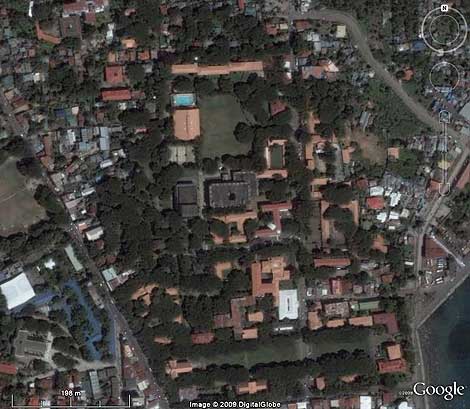
Here’s a non-exhaustive listing of places that have new hi-res satellite photos courtesy of DigitalGlobe: Aparri, Cagayan; Tuguegarao City, Cagayan; Infanta, Quezon; Naga City, Camarines Sur; Masbate City, Masbate; Iloilo City, Iloilo; most of Guimaras; Dumaguete City, Negros Oriental; Surigao City, Surigao del Norte; Lake Sebu, South Cotabato; Sarangani Islands, Davao del Sur; Culion, Palawan; and parts of Romblon. Shown above is Silliman University in Dumaguete.
Here’s a history of previous satellite imagery updates to Google Earth with representative places:
June 2005: Bulacan, Cavite, Pampanga
April 2006: Cagayan de Oro City, Davao City, Cotabato City, Butuan City, Bislig City
June 2006: Metro Manila, Laoag City, Pangasinan, Legazpi City, Cebu City, Bacolod City, Iligan City, Zamboanga City, Puerto Princesa City
October 2006: La Union, Batangas City, Puerto Galera, General Santos City, and CitySphere image of Metro Manila
February 2007: Magat Dam in Isabela, Tabaco City
June 2007: Honda Bay in Puerto Princesa
July 2007: northern Puerto Princesa
October 2007: Batanes, large parts of Bicol, Cuyo Island
Comments
Comments are currently disabled.