OpenStreetMap Cubao Mapping Party Post-Report
Dec 20 2009 Sun
4:55 am PHT
Last December 12, we had a Christmas OpenStreetMap Micro Mapping Party. The previous one was in Davao back in July and the first was in Tagaytay in May. Starting in 2010, we plan to have quarterly Mapping Parties at least in the Greater Manila Area. So if you’re interested to join one, there will be plenty of opportunities next year for you to do so.

For the December Mapping Party, we decided to tackle Cubao, particularly in the vicinity of the Araneta Center. Present were Maning, Neil, and me. Marloue, who was visiting Manila from Davao, was supposed to join us but he had a last-minute change of plans. Neil was accompanied by his wife and kid and Maning and I learned that they apparently map as a team, like the time when Neil practically completed the buildings in the Makati Central Business District.
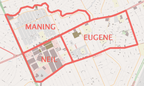
We met at Starbucks Araneta Coliseum and proceeded to “slice the cake”. This is an OpenStreetMap term in Mapping Parties where participants divide and assign the area to be surveyed. “Slicing the cake” is such a common expression in the worldwide OpenStreetMap community that there have been actual cakes with maps on them that were sliced as homage. Hehehe. Going back to Cubao, Maning took the “university slice”, namely, the portion north and east of EDSA and Aurora Boulevard that has famous world-famous universities as the names of its streets. Neil got Araneta Center itself—the area bounded by EDSA, Aurora, 15th Avenue, and P. Tuazon—so that it’d be safer for his family. I selected the portions east of 15th Avenue and ended up mapping up to J.P. Rizal between Aurora Boulevard and P. Tuazon. See the map below for the cake slices.
Unlike the Tagaytay Mapping Party, which involved surveying unmapped streets using GPS receivers, the Cubao Mapping Party is a Walking Papers-type of mapping. In Cubao, almost all of the streets have already been traced from Yahoo! satellite imagery and so what’s left is on-the-ground verification of road names and updated streets and extensive surveying for POIs or points of interest. This type of mapping has been called “Walking Papers” since there is an OSM-related site called Walking Papers that greatly facilitates such kind of mapping. In Walking Papers, you get a printable map of the area of interest, write and draw on the printed map while doing the actual mapping, then scan and upload the map where the site can automatically georeference it and have it also available for others to add to OpenStreetMap.
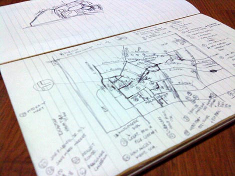
Maning had printed Walking Paper maps for his and Neil’s slices, but I didn’t (I have no working printer at home) so I reverted to the traditional pen-and-paper mapping, using my notebook to collect data. See the photo below to see some of my written notes. I have to say that having a printed Walking Papers map is much simpler since drawing the streets on the notebook loses much of the relative scale making it harder to place POIs. In addition, I should’ve used a spiral notebook since it’s easier to fold it to show the active pages. Oh well.
Anyway, I started my mapping in the block between 15th and 20th Avenues. It was pretty straightforward getting the POIs in the area. I wasn’t able to go inside the Princeton, Rochester, Trinity, and Monterrey streets since they were really narrow and I was driving a car. But I eventually parked along G.H. del Pilar street and walked a bit to get the names of a few townhouses in the area.
When I tackled the next block, the one between 20th Avenue and J.P. Rizal, boy was I in for a shock! Again, I tried mapping while driving slowly in my car and parking every now and then. But I eventually gave up, parked the car in front of Kalantiyaw Elementary School and did my mapping on foot. I walked most parts of the city block and was utterly flabbergasted by numerous alleys, footways, and streets. In addition I found many alleys and roads that have the same names! There were “Extension” and “Interior” streets there that are perpendicular or parallel to the original streets! If I were a delivery man, I’m sure I would get lost finding a house there if I wasn’t familiar with the area.
I checked various online and hardcopy maps (Google, Mapcentral.ph, Citiatlas, etc.) after the party and saw that not one had all the details that I had found when I surveyed the area. I guess OpenStreetMap now has the most detailed and up-to-date information of that area anywhere! 
The nicest place I visited while mapping was the Camerino Park in Barangay Marilag. I wasn’t really expecting to stumble into a park that has a playground filled with happy kids. If I were living in the area, that park would definitely be a great place to kill time.
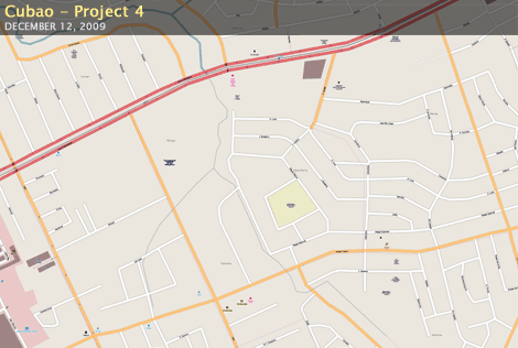
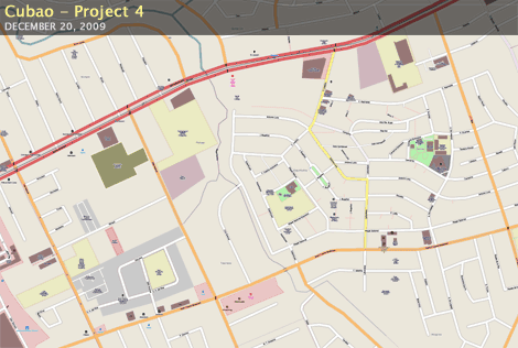
Shown below is the before-and-after screenshots of my map slice in OpenStreetMap. See how much nicer it now looks? Go check it out for yourself.
Comments
Comments are currently disabled.