KML of Ferdz Decena’s Batanes Maps
Jun 10 2008 Tue
12:53 am PHT
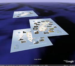
First of all, read Ferdz’ blog post. Then, if you have Google Earth, open this KML. Or if you don’t have Google Earth, you can check the KML out in Google Maps but take note that Google Maps doesn’t rotate image overlays so what you’ll see there won’t be accurate. Anyway, a screenshot of the KML as seen in Google Earth is shown to the side.
Ferdz’ maps of the three main islands of Batanes, which are Itbayat, Batan, and Sabtang, are quite excellently done. It’s a visual guide to Batanes using Ferdz’ own pictures taken during his trips there. As I mentioned before, Ferdz is one of the travel-photo bloggers I admire and these maps of his manage to mash-up his travel and photography passions and—being maps—piqued my interest as well.
So, I thought that the next step to upping these maps’ utility is to create a KML file containing these maps that can be viewed in Google Earth. While Ferdz did say that the maps are not drawn to scale, the islands were a pretty nice fit actually. The only major error I can see is the mislabeling of Y’ami Island (aka Mavudis Island and the Philippine’s northernmost island) on the Itbayat map—it’s supposed to be 20 kilometers more northern than in the map. Anyway, from the KML, you can clearly see that Batan and Sabtang are right next to each other while Itbayat is found more remotely to the north, giving a better perspective of Batanes.
The original maps are licensed by Ferdz under the Creative Commons BY-NC-ND 2.0 license, so the KML also has the same license. It’s debatable whether the KML can be considered as a derivative work of the original maps so I’m hoping that Ferdz would be cool with me possibly violating the ND (no derivatives) part of the license and giving an explicit permission instead. 
Comments
Comments are currently disabled.