The Graduation of Google Map Maker Philippines
Mar 29 2009 Sun
11:35 am PHT
Yuga once asked back in 2007, “Google, where’s our street maps?” Now the answer has come less than two years later when majority of the data contributed by Filipinos to Google Map Maker was recently pushed to Google Maps sometime in the latter half of February (see the official graduation announcement). To celebrate this milestone, Google held a press conference about two weeks ago. However, while what’s there right now in Google Maps for the Philippines is a vast improvement over the really laughable data before, there’s still room for improvement and Google needs to up its ante.
Press event coverage
Google held the press conference for the Philippines last March 12 in Makati. They even had a few Map Maker power users as guests to share their experiences and motivations for contributing and sharing geospatial information. Listed below are all the relevant links (blog posts, news article, photo albums, videos) that I can grab about this press launch.
“Philippine maps now available at Google”, news article by the Manila Standard Today
“Filipinos’ notes can now be seen on Google Maps”, news article from GMA News
“Google launches Filipino-made Google Maps”, news article from ABS-CBN News
“Filipinos make their mark on Google Maps”, news article by INQUIRER.net
“Mapping RP through Google”, news article from the Philippine Star
“Google links Philippine users to Google Maps”, news article by ZDNet Asia
“Google launches Filipino-made Google Maps”, news article from Newsbreak
“RP maps gets more detailed on Google”, video by GMANews.TV for QTV
“Google Updates Mapmaker in the Philippines”, blog post by Berniemack Arellano III, a Google Map Maker power-user
Press launch photo album by Berniemack
“Manila, Cebu, Davao and other cities now on Google Maps thanks to Map Maker”, blog post by Jayvee Fernandez
Still needs improvement
Not all of the data contributed in Google Map Maker made it to Google Maps. I guess Google has some internal criteria (likely maturity and stability) for choosing which data is ported to the public-facing Google Maps. Unfortunately this included a bunch of outdated data. Check out the comparison between Google Maps (not Map Maker) and OpenStreetMap of the Bonifacio Global City area below. (You can also check out an older version of the same comparison at the bottom of a post I did last year.) The OSM map shows what the roads should be looking like right now more or less.
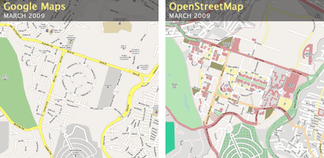
Until very recently, the data in Google Map Maker showed the same outdated streets as what you see in Google Maps now. Note in particular the circular roads at the middle which are the Bonifacio and Katipunan Circles. Bonifacio Circle and a large part of Katipunan Circle are no more and have been replaced with Ayala Land’s posh Bonifacio High Street strip mall. Fortunately in the past week, contributors in Google Map Maker (and I did my share too) have updated the data with the modern road layout.
As I mentioned in a previous post, the default satellite imagery in Google Maps shows this old circular layout which is why that’s what was reflected in Google Map Maker and is now in Google Maps. In the same previous post, I mentioned that despite Google having more recent imagery of this area, it chose to stick to an older satellite photo and this therefore had the unintended consequence of Google Maps showing old roads!
I think the major failing of Google is that it relies solely on its huge database of satellite imagery for Map Maker’s use. While that database is the most extensive on the planet (Yahoo! and Microsoft don’t even come close), it does not cover 100% of the inhabited parts of the planet and in some cases (like Metro Manila) shows outdated imagery. Without satellite imagery, Google Map Makers are out of luck trying to map things in detail, like Boracay, for which Google still does not have any high-resolution satellite imagery at all.
What Google should have done is to add intrinsic support for GPS tracks, something that OpenStreetMap has had since the very beginning and something that is really very trivial for Google to implement. With GPS support, people can add and update streets even without the aid of satellite imagery.
Comments
Comments are currently disabled.