Early 2008 Mapping News
Jan 25 2008 Fri
1:23 am PHT
Herewith are some mapping news to start the year.
Edushi, the Chinese Sim City
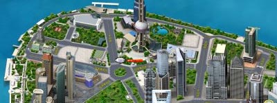
Benjamin de la Peña a.k.a. Urbano dela Cruz pointed me to this delicious visualization of Chinese cities called Edushi. As he has said, the graphics look like they came straight out of Sim City, and the interface is very much lifted from Google Maps (pannable [by dragging] and zoomable).
I was able to put this website to good use when I was searching for SM Xiamen so that I can feature it in Vista Pinas. I would really love to point out SM Xiamen in Edushi Xiamen here but I couldn’t locate the “link to this map” feature.

Anyway, I wanted to create graphics like this for Metro Manila (or at least the skyscraper-dense districts) and Edushi’s imagery is exactly how I envisioned it would be. Unfortunately, I realized that creating images like this is very time-consuming so I placed the idea in the back burner a long time ago.
Mapcentral adopts Google Maps’ interface; almost
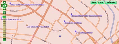
Mapcentral, possibly the most comprehensive online Pinoy GIS mapsite, has adopted the draggable map interface first popularized by Google Maps. In fact, they even imitated Google’s zoom-and-pan control widget on the upper-left corner of the map. Unfortunately, they didn’t copy the tile-based image management scheme of Google Maps, opting to stick with their old technology of completely redrawing the whole map window whenever you zoom or pan the map. Well, at least they used AJAX to load the new image instead of reloading the whole web page like before.
Accu-map releases new edition of their Metro Manila Citiatlas
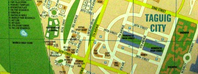
I raved about the 2006 edition of the Metro Manila Citiatlas by Accu-map over a year ago. They’ve released a new edition of their really high-quality atlas and I have no idea when they put this out into the market since the new edition has practically the same cover as the last one. (Each of their previous editions had a different cover from the previous one.) I just bought this beauty a while ago and this is the fourth Metro Manila Citiatlas I own. (Sorry, I’m a map geek. Hehehe. 
Unlike the 2006 edition (v4.0), which was a huge improvement over the 2004 edition, this new one (v4.2) doesn’t have any ground-breaking new features. It’s practically the same atlas but with updated geographical data. For example, the most striking change is the reconfiguration of Fort Bonifacio Global City, which includes the replacement of Bonifacio Circle with Bonifacio High Street (pictured above). Another is the refinement of the area in and around SM Mall of Asia. One nice touch is the clean-up of the runways of NAIA—the plane tracks are now depicted.
Additionally, there are a lot more school campuses highlighted as well as many more additional building footprints. Industrial buildings are also now distinguished by a new color from the commercial and residential buildings. (And they finally fixed the flyover error I pointed out before.)
Would I recommend this 2007 edition? Well, unless you’re a map fanatic like I am, I would say that you stick to the 2006 edition, if you have that. Otherwise, the 2007 edition is very fine pick if ever you’re in need of a Metro Manila map.
Comments
Comments are currently disabled.